In a groundbreaking development for coastal hazard assessment, researchers have harnessed the power of deep learning to detect rip currents from satellite imagery, offering a new tool for monitoring and understanding these dangerous coastal phenomena. The study, led by Yuli Liu from the School of Marine Sciences at Nanjing University of Information Science and Technology, introduces a sophisticated pipeline that could revolutionize how we assess and respond to rip currents, with significant implications for the energy sector and coastal management.
Rip currents are powerful, narrow currents that can pull swimmers away from the shore, posing a significant hazard to beachgoers. Traditional methods of detecting and monitoring rip currents often rely on near-real-time systems, which can be limited in their scope and accuracy. Liu’s research, published in the journal ‘Remote Sensing’ (translated as ‘Remote Sensing’), proposes a high-accuracy, offline analysis tool that leverages the broader geospatial context available in satellite imagery.
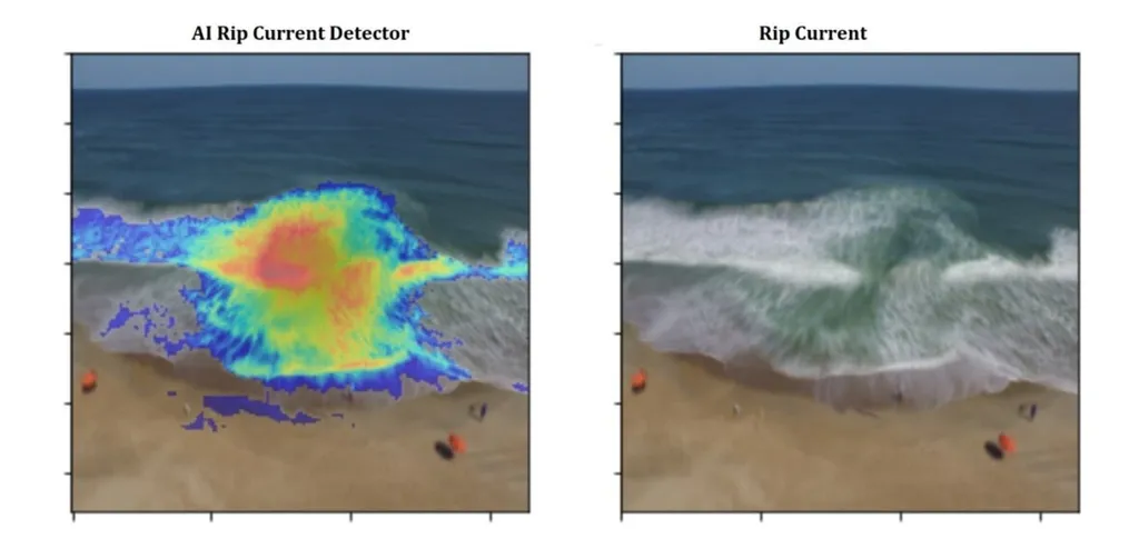
The pipeline developed by Liu and her team partitions high-resolution satellite images into smaller regions, where a deep learning object detection model identifies potential rip currents. The results are then merged and processed through a classification model to filter out non-beach scenes and remove spurious detections. This multi-step approach achieves an impressive overall accuracy of 98.4%, with a recall of 0.890 and an F2 score of 0.823, demonstrating its effectiveness in complex coastal scenes.
“This pipeline represents a significant advancement in our ability to detect and analyze rip currents,” said Liu. “By utilizing satellite imagery and deep learning, we can now assess rip currents with a level of accuracy and detail that was previously unattainable.”
The implications of this research extend beyond coastal safety. For the energy sector, particularly companies involved in offshore wind farms and coastal infrastructure, understanding rip currents is crucial for site selection, design, and maintenance. Accurate detection of rip currents can help in assessing the potential impacts on marine structures and ensuring the safety of personnel working in these environments.
Moreover, the study introduces a new dataset of far-view satellite imagery containing rip currents, which can be a valuable resource for further research and development in automated detection methods. “This dataset opens up new possibilities for improving our understanding of rip currents and developing more sophisticated detection algorithms,” Liu explained.
The research also sheds light on the conditions under which rip currents tend to occur. The findings suggest that rip currents are more likely to occur at open beaches under moderate-energy, onshore-directed wave conditions. This information can be invaluable for coastal management and planning, helping to mitigate risks and enhance safety.
As we look to the future, the pipeline developed by Liu and her team could pave the way for more advanced and automated systems for monitoring and assessing coastal hazards. By integrating deep learning with satellite imagery, we can unlock new insights into the dynamics of rip currents and other coastal phenomena, ultimately contributing to safer and more sustainable coastal environments.
In a world where climate change and rising sea levels are exacerbating coastal hazards, the need for accurate and reliable monitoring tools has never been greater. Liu’s research offers a promising solution, one that could shape the future of coastal hazard assessment and management. As the energy sector continues to expand into offshore and coastal areas, the ability to detect and understand rip currents will be increasingly important, making this research a valuable contribution to both scientific and industrial communities.