In the heart of India’s industrial landscape, the Jharia Coalfield has long been a symbol of the country’s economic growth, but at a significant environmental cost. A groundbreaking study led by Ajay Kumar from the Department of Computer Science & Engineering at Manipal University Jaipur, published in ‘Discover Geoscience’ (which translates to ‘Explore Earth Science’), is shedding new light on the region’s rapid land use changes and the impacts of mining activities. The research leverages the power of geospatial artificial intelligence (GeoAI) to offer a compelling narrative of environmental transformation and a roadmap for sustainable management.
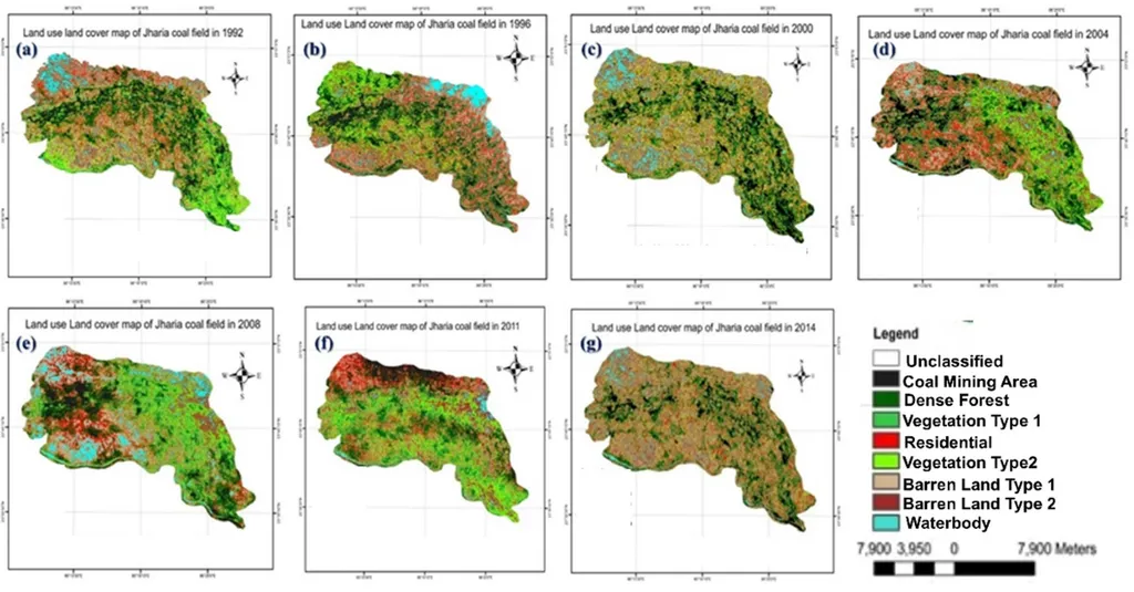
The study, which analyzed land use and land cover (LULC) changes over a 22-year period from 1992 to 2014, reveals a stark picture of the Jharia Coalfield’s evolution. Using a multi-method approach that integrates remote sensing, GIS, and GeoAI, Kumar and his team have uncovered significant spatiotemporal shifts in the region’s landscape. “The most striking finding is the consistent reduction in dense forest, water bodies, and barren land categories, coupled with a substantial increase in vegetation types and residential areas,” Kumar explains. This transformation highlights the dual pressures of urban encroachment and secondary vegetation regrowth in disturbed zones, painting a complex picture of environmental change.
The research underscores the urgent need for sustainable land management strategies and rigorous regulatory oversight. The transition matrix and classified maps generated by the study reveal a net decline of over 38% in dense forest and water bodies, while coal extraction zones have expanded considerably. This correlation between ecological deterioration and unplanned settlement growth is a critical insight for policymakers and industry stakeholders.
For the energy sector, the implications are profound. The study’s findings provide essential insights for policy formulation and environmental planning, emphasizing the need for long-term land-use planning to safeguard natural resources and rehabilitate degraded landscapes. “The application of remote sensing and GeoAI proves effective in generating accurate spatiotemporal statistics and delineating patterns of land degradation,” Kumar notes. This technological approach not only enhances our understanding of environmental impacts but also offers a powerful tool for monitoring and mitigating future damage.
The study’s comprehensive management plan for the Jharia Coalfield region is a beacon of hope for sustainable development. By integrating advanced geospatial technologies, the research paves the way for more informed decision-making and proactive environmental stewardship. As the energy sector continues to evolve, the insights gleaned from this study will be invaluable in shaping policies that balance economic growth with environmental conservation.
In a world where the impacts of industrialization are increasingly visible, this research serves as a reminder of the power of technology to illuminate the path forward. As Kumar and his team continue to explore the potential of GeoAI, their work is set to redefine the future of environmental monitoring and sustainable development in resource-extractive regions. The findings, published in ‘Discover Geoscience’, offer a compelling narrative of change and a roadmap for a more sustainable future.