In the ever-evolving world of remote sensing and geospatial technology, a groundbreaking study led by Zhe Zhao from Chang’an University in Xi’an, China, is set to revolutionize how we analyze high-resolution satellite imagery. The research, published in the IEEE Journal of Selected Topics in Applied Earth Observations and Remote Sensing (translated to English as “IEEE Journal of Selected Topics in Applied Earth Observations and Remote Sensing”), introduces a novel framework that addresses critical challenges in incremental learning for remote sensing semantic segmentation. This advancement could have profound implications for the energy sector, particularly in monitoring infrastructure, assessing environmental impacts, and optimizing resource management.
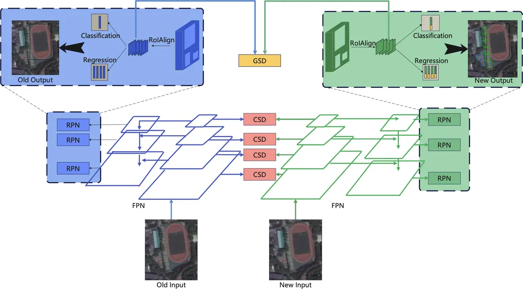
The study tackles the persistent issue of catastrophic forgetting, where machine learning models lose previously learned information when acquiring new knowledge. This problem is exacerbated in remote sensing due to the multiscale nature of land cover categories and the vast amount of data contained in high-resolution images. “The complexity of remote sensing data makes it particularly challenging to maintain model performance across multiple tasks,” explains Zhao. “Our approach ensures that models can learn new information without forgetting old classes, which is crucial for consistent and accurate analysis over time.”
The proposed framework, known as confidence-importance balanced replay and restricted knowledge distillation, employs a two-pronged strategy. First, it selects high-confidence samples from the model’s predictions in the current learning task, ensuring that the replayed data are both accurately labeled and feature-distinctive. This step is vital for maintaining the integrity of the data used for training. Second, it introduces importance-balanced replay, which computes importance values based on the global class distribution and per-task frequency. This ensures a more balanced selection of replay samples, mitigating data imbalance issues that are common in remote sensing datasets.
One of the most innovative aspects of the research is the use of restricted knowledge distillation. This technique preserves knowledge of old classes by restricting the distillation process to replay data without accessing new-class data. “By doing so, we effectively address background shift and maintain segmentation consistency across tasks,” Zhao notes. This consistency is particularly valuable in the energy sector, where accurate and reliable data are essential for decision-making processes.
The study’s findings are backed by extensive experiments on high-resolution remote sensing datasets, Vaihingen and Potsdam, demonstrating significant improvements over existing state-of-the-art incremental learning approaches. The implications for the energy sector are vast. For instance, energy companies can use this technology to monitor the health of solar farms, assess the environmental impact of oil and gas operations, and optimize the placement of wind turbines. The ability to maintain consistent and accurate data analysis over time is a game-changer for industries that rely on precise geospatial information.
As the world continues to grapple with climate change and the need for sustainable energy solutions, the ability to analyze and interpret remote sensing data accurately has never been more critical. Zhao’s research represents a significant step forward in this field, offering a robust framework that can adapt to the dynamic nature of remote sensing data. “Our goal is to provide a reliable tool that can be integrated into various applications, from environmental monitoring to urban planning,” Zhao says. “The potential for impact is enormous.”
In conclusion, this research not only addresses a fundamental challenge in machine learning but also opens up new possibilities for the energy sector. As the technology continues to evolve, we can expect to see even more innovative applications that leverage the power of remote sensing data to drive sustainable development and informed decision-making. The future of geospatial technology is bright, and Zhao’s work is a beacon of progress in this exciting field.