In the rugged, mountainous terrain of Lanping County, southwestern China, a silent and often unseen threat looms: landslides. These geological disasters pose significant risks to lives, property, and the delicate ecological balance of the region. However, a groundbreaking study led by Yongfa Li from the Kunming University of Science and Technology is shedding new light on these hazards, offering a scientific foundation for disaster prevention and control that could have far-reaching implications for the energy sector and beyond.
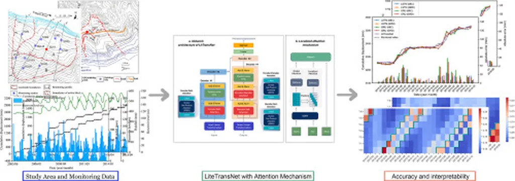
Lanping County’s complex geographical environment, significant vertical climate variation, and fragile geological conditions make it a hotspot for landslides. Traditional methods of monitoring and predicting these events have often fallen short, but Li and his team have turned to advanced remote sensing technologies to change the game. By combining the Layover Shadow Map (LSM) and Range Index (R-Index) methods, they have systematically analyzed geometric distortions in Sentinel-1A satellite images, providing a clearer picture of the region’s terrain.
The team then employed the Small Baseline Subset (SBAS) Interferometric Synthetic Aperture Radar (InSAR) technique to extract surface deformation information over a three-year period, from January 2021 to December 2023. This data, integrated with optical remote sensing images, allowed them to identify potential landslide hazards with unprecedented accuracy. “By leveraging these advanced technologies, we were able to detect 258 potential landslide hazards, including 184 that were previously unknown,” Li explained. “This comprehensive approach not only enhances our understanding of the region’s geological risks but also paves the way for more effective disaster management strategies.”
The implications of this research extend far beyond Lanping County. In the energy sector, where infrastructure development often involves navigating complex and challenging terrains, the ability to accurately predict and mitigate landslide risks is invaluable. Oil and gas pipelines, hydroelectric power plants, and other critical energy infrastructure are particularly vulnerable to the devastating impacts of landslides. By providing a more precise and up-to-date hazard distribution map, this research can help energy companies make informed decisions, reduce risks, and ensure the safety and sustainability of their operations.
Moreover, the integration of InSAR and optical imaging techniques represents a significant advancement in the field of geological hazard monitoring. As Li noted, “This study demonstrates the potential of combining different remote sensing technologies to improve our understanding of surface deformation and landslide mechanisms.” This interdisciplinary approach could inspire future research and development in the field, leading to more sophisticated and reliable methods for predicting and managing geological disasters.
The study, published in the journal ‘Geomatics, Natural Hazards & Risk’ (translated to English as ‘Geomatics, Natural Hazards & Risks’), underscores the importance of leveraging cutting-edge technologies to address complex environmental challenges. As the energy sector continues to expand into increasingly remote and geologically complex regions, the ability to accurately assess and mitigate risks will be crucial. Li’s research not only provides a valuable tool for disaster prevention and control but also sets a new standard for the integration of remote sensing technologies in geological hazard monitoring.
In an era where climate change and human activity are exacerbating the risks of natural disasters, the work of researchers like Yongfa Li offers a beacon of hope. By harnessing the power of advanced technologies, we can better understand and mitigate the threats posed by landslides, ensuring the safety and sustainability of our communities and critical infrastructure. As the energy sector continues to evolve, the insights gained from this research will be invaluable in shaping a safer and more resilient future.