In a groundbreaking development for the geospatial and energy sectors, researchers at the Technical University of Munich have unveiled the GlobalBuildingAtlas, a comprehensive and open dataset that promises to revolutionize how we understand and interact with global building infrastructure. Led by Dr. X. X. Zhu, this initiative marks the first time a dataset of this scale and precision has been made publicly available, offering unprecedented insights into the world’s built environment.
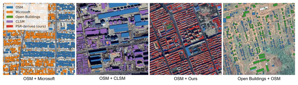
The GlobalBuildingAtlas provides detailed 2D and 3D building models, including polygons, heights, and Level of Detail 1 (LoD1) 3D models, for over 2.75 billion buildings worldwide. This dataset surpasses existing databases by more than a billion buildings, offering a spatial resolution of 3m x 3m—30 times finer than previous global products. “This level of detail and accuracy opens up new possibilities for geospatial analysis and urban planning,” Dr. Zhu explains. “It allows us to better understand where people live and monitor progress on sustainable development goals.”
The implications for the energy sector are profound. Accurate building data is crucial for energy modeling, urban planning, and renewable energy integration. With precise building heights and footprints, energy providers can optimize solar panel installations, assess wind energy potential, and improve energy efficiency in urban areas. “This dataset can help us create more efficient energy systems,” Dr. Zhu notes. “By understanding the built environment at this level of detail, we can make more informed decisions about energy distribution and consumption.”
The creation of the GlobalBuildingAtlas involved innovative machine learning pipelines to derive building polygons and heights from global PlanetScope satellite data. A quality-based fusion strategy was employed to generate higher-quality polygons, ensuring the dataset’s accuracy and reliability. The resulting LoD1 building models, with a height completeness of over 97%, offer a reliable foundation for various applications, from disaster response to smart city planning.
Published in the journal ‘Earth System Science Data’ (translated to English as ‘地球系统科学数据’), this research represents a significant leap forward in geospatial technology. The dataset is now available to the public, inviting researchers, urban planners, and energy professionals to explore its potential. As Dr. Zhu puts it, “This is just the beginning. The possibilities are endless, and we are excited to see how this dataset will shape the future of geospatial analysis and energy planning.”
The release of the GlobalBuildingAtlas is a testament to the power of open data and innovative technology. As we move towards a more sustainable and energy-efficient future, this dataset will undoubtedly play a pivotal role in shaping our understanding of the built environment and guiding strategic decisions in the energy sector.