In the bustling urban landscapes of the future, the ability to accurately map and reconstruct buildings is becoming increasingly vital for a range of applications, from disaster management to the development of digital twins. A groundbreaking study led by Jia Li from the School of Earth Sciences and Engineering at Hohai University in Nanjing, China, is set to revolutionize this field. Published in the journal *Remote Sensing* (translated from Chinese as “Remote Sensing”), the research introduces a novel framework that leverages backpack LiDAR technology to extract building footprints with unprecedented accuracy.
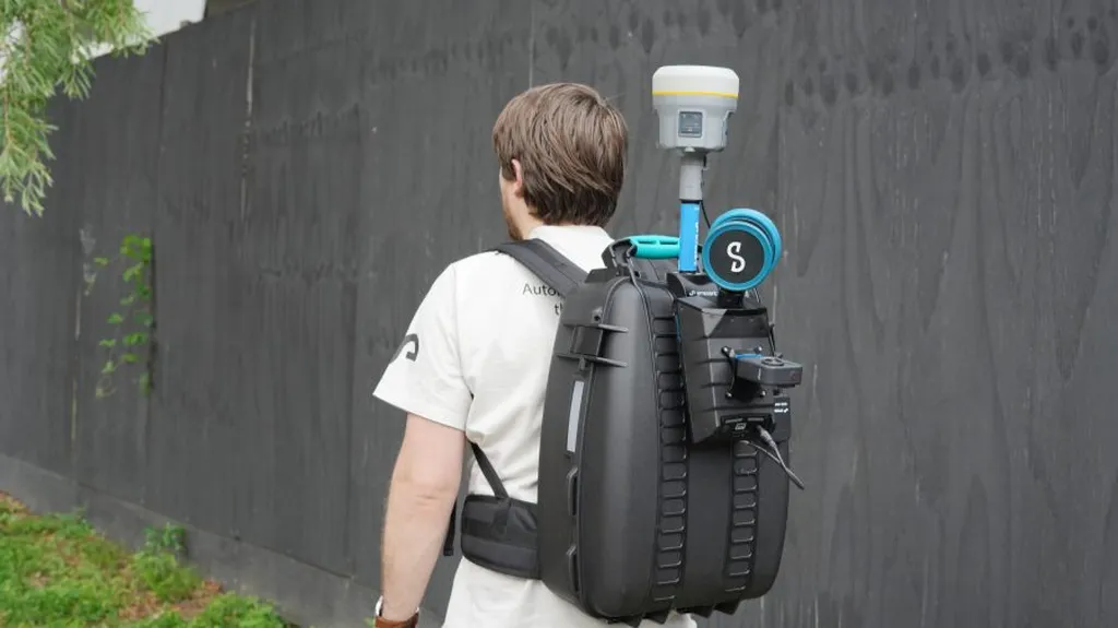
Traditional methods of building footprint extraction have relied heavily on image-based approaches, which, while effective on a large scale, are limited by their 2D perspective and susceptibility to radiometric distortions. Airborne or vehicle-borne LiDAR systems, on the other hand, often struggle with single-viewpoint constraints, resulting in incomplete or fragmented footprints. Enter backpack mobile laser scanning (MLS), a flexible and innovative platform that captures dense urban geometry at the pedestrian level. However, the high noise, point sparsity, and structural complexity of MLS data have posed significant challenges to reliable footprint delineation—until now.
Li and her team have developed a Deep Line-Segment Detection–Driven Building Footprints Extraction Framework that integrates multi-layer accumulated occupancy mapping, deep geometric feature learning, and structure-aware regularization. This sophisticated approach aggregates stable wall features from multiple height slices to enhance contour continuity and suppress random noise. A deep line-segment detector then extracts robust geometric cues from noisy projections, achieving accurate edge localization and reducing false responses. Finally, a structural chain-based completion and redundancy filtering strategy repairs fragmented contours and removes spurious lines, ensuring coherent and topologically consistent footprints reconstruction.
The results are nothing short of impressive. Extensive experiments conducted on two campus scenes containing 102 buildings demonstrated that the proposed method achieves an average Precision of 95.7%, Recall of 92.2%, F1-score of 93.9%, and IoU of 88.6%. These metrics represent a significant improvement over existing baseline approaches, outperforming them by 4.5–7.8% in F1-score.
So, what does this mean for the energy sector and beyond? Accurate building footprints are essential for updating GIS databases, monitoring land use, and managing disasters. They also play a crucial role in the development of digital twins, which are virtual replicas of physical systems used for simulation, analysis, and decision-making. “This research highlights the strong potential of backpack LiDAR point clouds, when combined with deep line-segment detection and structural reasoning, to complement traditional remote sensing imagery and provide a reliable pathway for large-scale urban scene reconstruction and geospatial interpretation,” Li explained.
The implications for the energy sector are particularly compelling. As cities continue to grow and evolve, the need for efficient and sustainable energy management becomes ever more pressing. Accurate building footprints enable better urban planning, which in turn supports the integration of renewable energy sources and the optimization of energy distribution networks. Moreover, the ability to quickly and accurately assess building structures can aid in the deployment of energy-efficient technologies and the retrofitting of existing buildings.
Looking ahead, this research paves the way for future developments in the field of urban scene reconstruction. By combining the flexibility of backpack LiDAR technology with advanced deep learning techniques, Li and her team have opened up new possibilities for capturing and interpreting the complex geometries of urban environments. As the technology continues to evolve, we can expect to see even more innovative applications emerge, shaping the cities of tomorrow and transforming the way we interact with our built environment.
In the words of Li, “The integration of deep learning and mobile LiDAR technology represents a significant step forward in our ability to understand and navigate the urban landscape. This research not only advances the field of remote sensing but also has the potential to drive meaningful change in how we plan, manage, and sustain our cities.”