In the heart of Stuttgart, a city known for its industrial prowess and technological innovation, a groundbreaking approach to subsurface data management is taking shape. Researchers, led by K. Pusacker from the Regierungspräsidium Freiburg’s State Authority for Geology, Mineral Resources and Mining (LGRB), are pioneering a method to integrate urban and geological data like never before. Their work, published in the ‘Annals of the Photogrammetry, Remote Sensing and Spatial Information Sciences’ (a journal focused on photogrammetry, remote sensing, and spatial information sciences), is set to revolutionize how we understand and interact with the subsurface, with significant implications for the energy sector.
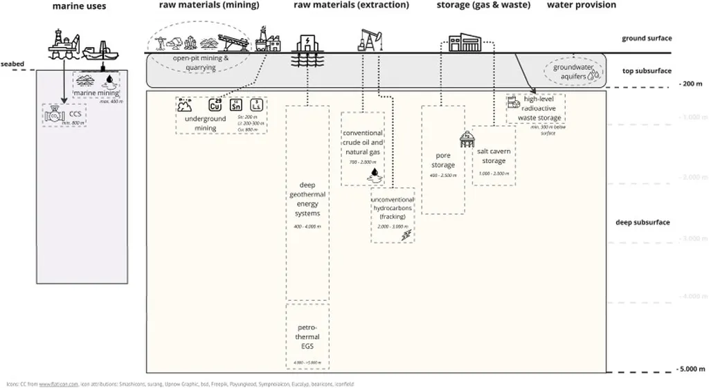
The challenge at hand is monumental. Urban areas are complex, with a tangled web of buildings, infrastructures, and geological structures. Each element holds crucial information, but integrating these disparate data sets has been a formidable task. “The existing data model schemas can manage various types of subsurface data,” Pusacker explains, “but they often fall short when it comes to combining urban and geological information in a way that’s useful for 3D voxel modeling.”
Pusacker and his team are tackling this issue head-on. They’re developing a data model schema tailored to urban and geological subsurface models, building upon existing structures like the Geoscience Markup Language (GeoSciML) and City Geography Markup Language (CityGML). This integrated approach allows for a more comprehensive understanding of the subsurface, paving the way for more informed decision-making in urban planning and energy exploration.
The implications for the energy sector are profound. Accurate subsurface modeling is crucial for identifying potential energy resources, planning extraction strategies, and mitigating environmental impacts. By providing a more holistic view of the subsurface, this research could significantly enhance the efficiency and sustainability of energy projects.
Moreover, the integration of urban and geological data could facilitate better risk assessment and management. As cities continue to grow and energy demands increase, understanding the interplay between urban development and geological structures becomes ever more critical. This research could help prevent potential conflicts and ensure that urban expansion is sustainable and safe.
The case study in Stuttgart serves as a testament to the potential of this approach. By applying their data model to the city’s complex subsurface, Pusacker and his team have demonstrated its practical utility. Their work is not just about advancing scientific understanding; it’s about providing tools that can be used in the real world to drive progress and innovation.
As we look to the future, the potential applications of this research are vast. From improving urban planning to enhancing energy exploration, the integrated data model schema developed by Pusacker and his team could be a game-changer. It’s a testament to the power of interdisciplinary collaboration and a shining example of how technology can be harnessed to tackle complex challenges.
In the words of Pusacker, “This is just the beginning. The construction and integration of model elements within a framework that comprises modeling, data management, and visualization tools opens up a world of possibilities.” And indeed, as we stand on the precipice of a new era in subsurface data management, the possibilities seem endless.