In the heart of Yunnan Province, China, a groundbreaking study led by Jiaxiang Tian from the School of Geography and Information Engineering at China University of Geosciences (Wuhan) and the Innovation Academy for Precision Measurement Science and Technology, Chinese Academy of Sciences, is revolutionizing how we monitor and understand terrestrial water storage (TWS). The research, published in the journal *Geodesy and Geodynamics* (translated as “Geodesy and Geodynamics”), leverages the Global Navigation Satellite System (GNSS) to provide more accurate and detailed hydrological data, with significant implications for the energy sector and climate monitoring.
Tian and his team have developed a novel strategy to extract hydrological load deformation from GNSS observations. By removing seasonal hydrological load signals from the raw data and applying principal component analysis (PCA), they have significantly improved the accuracy of TWS monitoring. “The spatial distribution of the root mean square error (RMSE) is improved by approximately 15% compared with traditional PCA extraction from raw data,” Tian explains. This enhanced precision is a game-changer for industries that rely on accurate water storage data, including hydropower, agriculture, and water resource management.
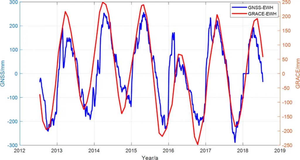
The study analyzed data from 24 GNSS stations in Yunnan Province from January 2013 to December 2022. The results showed that the spatial distribution and time series of TWS inverted from GNSS align well with those inferred from the Gravity Recovery and Climate Experiment (GRACE), GRACE Follow-On (GFO), and the Global Land Data Assimilation System (GLDAS) land surface model. However, the amplitude of the GNSS-inverted TWS is slightly higher, indicating that GNSS ground stations are more sensitive to hydrological load signals.
“This higher sensitivity means that GNSS observations can capture higher-frequency hydrological signals, which is crucial for understanding climate extremes and their impact on water resources,” Tian notes. The study found that GNSS observations show correlations with precipitation data that are 8.6% and 6.0% higher than those of GRACE and GLDAS, respectively. Additionally, the power spectral density analysis revealed that the signal strength of GNSS is much higher than that of GRACE/GFO and GLDAS in the June and February cycles.
The implications of this research are far-reaching. For the energy sector, particularly hydropower, accurate TWS monitoring is essential for predicting water availability and optimizing power generation. “By providing more precise and timely data, GNSS-based TWS monitoring can help energy companies make better decisions, improve efficiency, and reduce risks associated with water resource management,” Tian explains.
Moreover, the ability to capture higher-frequency hydrological signals can enhance climate monitoring and prediction, enabling better preparation for extreme weather events. “This research demonstrates the potential of GNSS TWS in addressing limitations in GRACE/GFO observations and provides a valuable tool for climate and hydrological studies,” Tian concludes.
As the world grapples with the impacts of climate change, the need for accurate and reliable hydrological data has never been greater. Tian’s research offers a promising solution, paving the way for more effective water resource management and climate monitoring. With the continued advancement of GNSS technology and data analysis techniques, the future of hydrological monitoring looks brighter than ever.